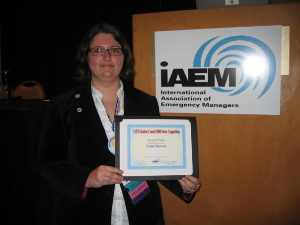
Award-winning graduate research from 2008 that moved public-assistance disaster assessments from pencil and paper to a mobile workflow—then went into the field in 2009.
IAEM Student Council poster competition / Second place / 2008
University of North Florida / Graduate research
Cell Phone Based Technology for Public Assistance Disaster Assessments
Public Assistance is the basis of disaster recovery. This project reimagined its first step—the Preliminary Disaster Assessment—as a mobile, structured, geocoded field workflow.
2nd placeInternational Association of Emergency ManagersStudent poster competition / 2008
The problem
A disaster clock. A pencil. A stack of paper.
Preliminary Disaster Assessments were being recorded by hand in the field: tedious during the assessment, difficult to consolidate later, and disconnected from the maps decision-makers needed. The project adapted existing special-needs assessment technology for the Public Assistance workflow instead of waiting for a bespoke system to appear.
The proposed system
From the field to a decision-ready map.
01
Capture
Local, state, and federal assessors enter preliminary damage information into a field-ready form on a cell phone instead of juggling pencil, paper, and later transcription.
02
Transmit
The submission travels to a central facility designed to operate independently from the infrastructure already disrupted by the disaster.
03
Structure
Field submissions become a usable Excel dataset, reducing the delay and mistakes introduced when handwritten notes must be re-entered after the fact.
04
Map
Locations are geocoded in a custom GIS application so recovery teams can see damage patterns, coordinate assessment, and move toward Public Assistance faster.
Not a classroom-only concept
Then it went into the field.
In June 2009, while working as a Public Assistance Coordinator for the Florida Division of Emergency Management, I tested the Pathfinders technology during real Preliminary Disaster Assessments in Putnam and Clay counties. The phones helped document what the assessment team inspected and discussed as we moved through the field—not just what someone could reconstruct later from handwritten notes.
What the test produced
Receipts from the field, not a lab demo.
01
Phone-entered records
Structured Public Assistance assessment information captured on the device while the work was happening.
02
Sortable data
A compiled Excel workbook containing the information entered through the mobile forms.
03
Operational visibility
Monitoring-software screenshots and a video track showing movement through the assessment day.
04
The next iteration
More field trials, with geocoded photographs added to connect observations, evidence, and place.
Archived email and field-test artifacts dated June 19, 2009.
What the judges saw
“A great integration of technology” addressing “a real-world problem.”
The judges pushed the work toward two durable product questions: could the field interface be simple enough to require no training, and could the back end turn submissions into a useful, robust end format?
They saw at least three research paths hiding inside the project:
A no-manual field interface
A robust data integration layer
Real-world alpha, beta, and implementation research
ARCHIVE GAPOriginal technical posterLast known location: possibly the basement
Basement archaeology pending
The evidence we have now. More when the poster resurfaces.
The award photo, original abstract, 11 device photos, sortable field-test workbook, system screenshots, movement-tracking video, and judges' notes establish the project and its impact. The original poster and technical diagrams will be added here if the physical archive cooperates.
Back to the receipts
Emergency management was systems engineering before I called it systems engineering.